Poster: A snowHead
|
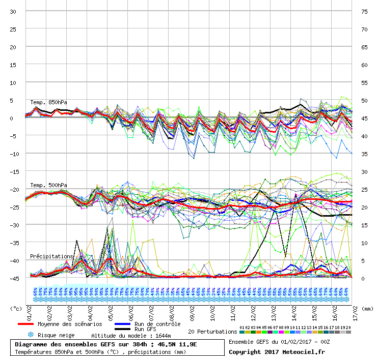
If we look at the ensembles here for just south of the Dolomites, it's easy at first glance to say, whoohoo look at all that snow over the next few days. Certainly the ensemble-mittel looks promising.
But then look at the hauptlauf or main run and you can see that it's barely showing any precipitation at all.
So am I reading that correctly? All the variation runs are suggesting lots of snow but the main run is saying, nah, nothing much is going to happen? It just seems surprising to me.

|
|

|
|
|
|
Obviously A snowHead isn't a real person
Obviously A snowHead isn't a real person
|
| olderscot wrote: |
If we look at the ensembles here for just south of the Dolomites, it's easy at first glance to say, whoohoo look at all that snow over the next few days. Certainly the ensemble-mittel looks promising.
But then look at the hauptlauf or main run and you can see that it's barely showing any precipitation at all.
So am I reading that correctly? All the variation runs are suggesting lots of snow but the main run is saying, nah, nothing much is going to happen? It just seems surprising to me.
|
Its sometimes hard to distinguish wether the green line is the operational run or one of the ensemble runs. In this case I would agree that the operational run (slightly thicker green line) is showing little precipitation.
As to why its so different to most of the ensemble runs at that short range, I can't answer, but it's no suprise!! Over the past few years I have seen this several times for the Dolomites and at shorter ranges as well (sometimes up to 24 hours). From memory, the operational run usually ends up being closest to what actually happens on the day, but not on every occasion.
|
|
|
|
|
|
Well, the person's real but it's just a made up name, see?
Well, the person's real but it's just a made up name, see?
|
I guess it just seems strange to me because we're always hearing that we should be looking for support for the main run to get some confidence in it's probabilty.
Here all the support seems to be for something different from the main run!
|
|
|
|
|
|
You need to Login to know who's really who.
You need to Login to know who's really who.
|
|
@olderscot, in which case you cannot have high confidence in the operational run (though nor should you ignore it). Weather being complex you are always looking at shades of confidence and uncertainty.
|
|
|
|
|
|
Anyway, snowHeads is much more fun if you do.
Anyway, snowHeads is much more fun if you do.
|
I have a vested interest in this and have been following it closely...
It looks like a lot of moisture is forecast to enter N Italy by Friday & over the weekend. It's not an even front sweeping through as such, but seems to be in a series of heavy, but isolated snowstorms, so some places are seeing considerable accumulations on the forecasts and others are seeing very little.
On today's Wepowder maps, I notice Madesimo in Lombardy Alps with 76 cm predicted, yet Val Gardena not too far away in the Dolomites with only 2cm.
http://wepowder.com/forecast
A small shift in the storm tracks and everything could be different, it looks a very unpredictable scenario, the ensemble runs are hinting at that and I expect it to keep changing on the forecasts as it approaches, I guess we'll probably in the end just have to wait & see what turns up!
Freeze levels are a bit of a worry too, this is quite mild weather popping up out of the Med.
|
|
|
|
|
|
You'll need to Register first of course.
You'll need to Register first of course.
|
@nozawaonsen, thanks, I know deep down you're right as always. All this is really showing is that there's a lot of uncertainty and that many of the possibilities could lead to some decent snowfall.
I'll be interested to see in which direction it all converges. Recent forecasts for this region have shown similar variations, only for them all to collapse down to the GFS main run which has tended to be the less favourable outcome.
|
|
|
|
|
|
|
|
Morris on Wepowder hints at the turbulent weather at the end of the week on his commentary here...and just contents himself with saying 'The next storm will bring lots of snow to the southern Alps'
http://wepowder.com/forum/topic/238525
|
|
|
|
|
|
|
|
@luigi, that does look interesting though his explanation expects it focus more on the western side of the italian alps.
| Quote: |
The next storm will bring lots of snow to the southern Alps
The small T that you can see on the map above in the Gulf of Genoa will develop itself into an independent storm that will bring lots of snow to the resorts south of the main alpine ridge between Friday and Sunday. Moist air hits the southern side of the main alpine ridge and you can expect a lot of snow in the southern French Alps and northwestern Italy. The first front will kick in on Thursday. This front is still a bit 'weak', but is followed by a much stronger front on Friday. The snow line will drop to 900-1200 meters, locally even lower. Another front will hit these regions on Saturday and you can also expect more snow on Sunday. I expect that because of the intensity of the fronts the expected amounts of snow on the south side of the Alps will increase even further the next couple of days!
|
|
|
|
|
|
|
You'll get to see more forums and be part of the best ski club on the net.
You'll get to see more forums and be part of the best ski club on the net.
|
Better stock up with Haribo and kindle books for the transfer to the BB then 
|
|
|
|
|
|
|
|
The 06Z run looks even more interesting with things starting to happen in the GFS run too.

|
|
|
|
|
|
snowHeads are a friendly bunch.
snowHeads are a friendly bunch.
|
| olderscot wrote: |
| @luigi, that does look interesting though his explanation expects it focus more on the western side of the italian alps. |
Yes, when you look at his current set of maps, the precipitation certainly looks focused on the S French Alps, particularly the Alpes Maritimes & the Ecrins, the extreme SW of Piedmont, a great arc from the Monte Rosa across the Swiss Ticino to the Lombardy Alps and just one eastern hotspot in the Julian Alps in Slovenia.
http://wepowder.com/forecast?region=1
On those maps, the Dolomites look to be the driest mountains of any 2000+m range in the Italian Alps. I think the western half of the Italian Alps are catching more is because it is closer to the source of the moisture in the Gulf of Genoa. The Dolomites tend to do significantly better out of systems that source moisture from the N Adriatic, though with the Julians getting pasted, Adriatic moisture is likely a player.
The coordinates for your GFS chart relate to a position well south of the Central Dolomites in the Venetian Pre-alps near Feltre. I would expect these to catch more precip from a SW weather system than areas further N. This link will produce a GFS chart close to Arabba coordinates:
http://www.meteociel.fr/cartes_obs/gens_display.php?ext=1&lat=46.49&lon=11.87
I'm sure these forecasts are going to shift around a lot before the end of the week as this all looks very unpredictable & turbulent. There's certainly going to be a lot of rain around the Po plain and the rivers will be flowing.
|
|
|
|
|
|
And love to help out and answer questions and of course, read each other's snow reports.
And love to help out and answer questions and of course, read each other's snow reports.
|
| Quote: |
The coordinates for your GFS chart relate to a position well south of the Central Dolomites in the Venetian Pre-alps near Feltre.
|
True. It's a shame we can't be more specific with these charts as I just don't find the more geographically specific ones nearly as good. I like to use the charts to get a view of the predicted weather activity over a 3-10 day horizon and the larger scale and better contrast makes it much clearer to me how much variability there is in the models.
| Quote: |
I'm sure these forecasts are going to shift around a lot before the end of the week as this all looks very unpredictable & turbulent.
|
It is looking like it, isn't it. There should be a lot happening so here's hoping at least some it reaches the Dolomites.
|
|
|
|
|
|
|
|
More huge disparities here on 18Z GFS 180hr snow accumulation charts...
http://www2.wetter3.de/Animation_06_UTC_05Grad/180_24.gif
135cm on the Monte Rosa, 103cm on the Adamello, 56cm in the Cadore, but what?approx 10cm in the Dolomites in between??
I know these amounts are indicative, just got to hope the joy is spread a bit more evenly when it arrives! 
|
|
|
|
|
|
You know it makes sense.
|
|
@luigi, firstly that's the 06z running up to 18z next Monday. Secondly those charts are very liable to change.
|
|
|
|
|
|
Otherwise you'll just go on seeing the one name:
Otherwise you'll just go on seeing the one name:
|
@nozawaonsen, thanks for the comments & corrections!
Yes, I think we're all expecting & hoping the forecasts shift around before the end of the week.
|
|
|
|
|
|
Poster: A snowHead
|
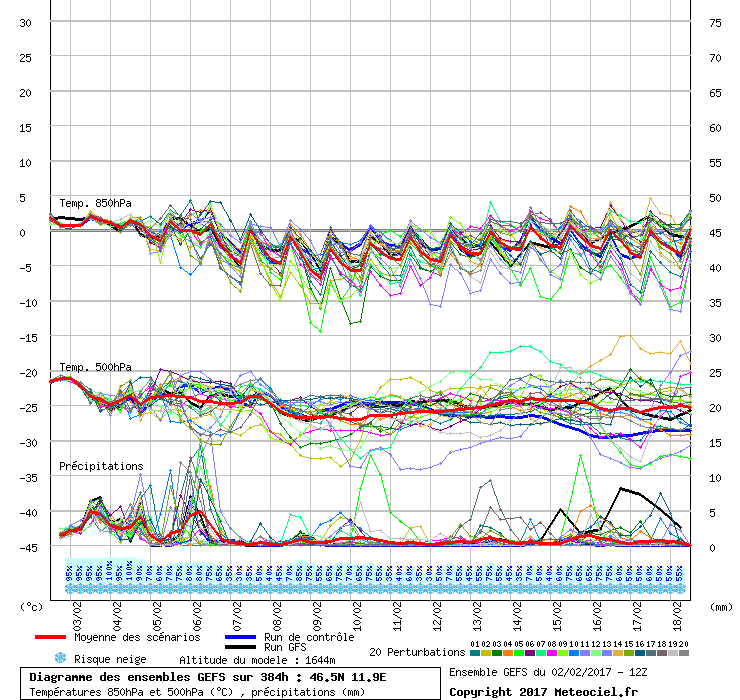
I'm updating the thread just to keep track of how the ensembles evolve as we get closer. There's still lot's of variation in the ensembles but the GFS main run is still very quiet for the next few days though now supporting heavy snowfall overnight on Saturday / early Sunday. This is also showing in the forecast for Corvara on snow-forecast.com

PS. Apologies to Luigi and everyone else for this thread which overlaps with the main Dolomites weather thread. I think this one on how the ensembles evolve versus the GFS main run is probably best kept separate.
|
|
|
|
|
|
Obviously A snowHead isn't a real person
Obviously A snowHead isn't a real person
|
| olderscot wrote: |
PS. Apologies to Luigi and everyone else for this thread which overlaps with the main Dolomites weather thread. I think this one on how the ensembles evolve versus the GFS main run is probably best kept separate. |
No need to apologise, it will be interesting to compare and look back after the event.
|
|
|
|
|
|
Well, the person's real but it's just a made up name, see?
Well, the person's real but it's just a made up name, see?
|
If I was to summarise the trend for this mornings ensembles, I'd say it looks to me as if the main run GFS is now supporting two of the three events that the mass of variation ensembles have been showing as a possibility.

|
|
|
|
|
|
You need to Login to know who's really who.
You need to Login to know who's really who.
|
|
|
|
Anyway, snowHeads is much more fun if you do.
Anyway, snowHeads is much more fun if you do.
|
Todays update of the ensembles still shows the same fronts it did earlier in the week (which I think is quite impressive given the recent volatility in the weather) but does reduce the precipitation they might bring. Again, the GFS main run is showing signs of supporting the rest of the ensembles, which is a change from the beginning of the week. We're getting very close to the predicted snowfall so it will be interesting to see what finally happens.

|
|
|
|
|
|
You'll need to Register first of course.
You'll need to Register first of course.
|
| olderscot wrote: |
| If we look at the ensembles here for just south of the Dolomites, |
46/12 is nearer Venice than the Dollies and gets totally different weather. What you want is 46.5/11.5
|
|
|
|
|
|
|
|
|
|
|
|
|
| Quote: |
46/12 is nearer Venice than the Dollies and gets totally different weather. What you want is 46.5/11.5
|
@red 27, yup. We've already discussed that. This thread is really about the variation in the ensembles and why the GFS main run was forecasting one thing when the rest of the ensembles were saying something else.
At the end of the day it's hard to draw any sort of conclusions. For most of the fronts / precipitation events the GFS main run did rise to meet the rest of the ensembles but they really sort of merged to meet at a compromise level. We're definitely ending up with more snow than the main run GFS was predicting at the start of the week so in that respect the mass of ensembles was a better predictor than the main run GFS.
It's almost as if the main run GFS is deliberately cautious until things become clearer, but we know that isn't the case as we sometimes see huge, unsupported main run GFS forecasts in the FI.
So not much learned really. Other than that the mass of ensembles can be a reasonable indicator if they all support each other, even when the GFS main run doesn't. Maybe that's a reasonable outcome for a single week's following of the ensembles.
|
|
|
|
|
|
|
|