 Poster: A snowHead
|
|
|
|
Obviously A snowHead isn't a real person
Obviously A snowHead isn't a real person
|
Extracts from this evening’s SLF outlook for Switzerland [my bold]. Worth noting how the likely temperatures change from north to south.
“Observed weather on Sunday, 10.12.2017
Following a night of predominantly clear skies, precipitation set in rapidly from the west during the early morning hours. The snowfall level ascended to nearly 1000 m by afternoon.
Fresh snow
By Sunday afternoon, the following amounts of snowfall were registered:
in the Valais not including the valleys of Visp and not including the Simplon region: 15 to 30 cm;
in the western sector of the northern flank of the Alps, in the valleys of Visp and in the Simplon region: 5 to 15 cm;
in the other regions of Switzerland: less.
Temperature
At midday at 2000 m, -1 °C in northern regions, -12 °C in southern regions.
Wind
Winds were southwesterly, on Saturday night and Sunday morning intensifying significantly, at midday blowing at strong to storm strength, in the alpine valleys of the north as foehn wind.
Weather forecast through Monday, 11.12.2017
On Sunday night, the precipitation on the northern flank of the Alps will slacken off incrementally. During the morning on Monday, it is expected to be predominantly dry in northern regions. In the afternoon, renewed precipitation will set in from the west and the south. The snowfall level will lie between 1800 and 2500 m to begin with. As evening approaches, the snowfall level is expected to descend significantly. On the Main Alpine Ridge and southwards therefrom, snowfall all day long is anticipated, most of it in the zone between Lukmanier Pass and Val Müstair and southwards therefrom. During the afternoon, the precipitation is expected to intensify. The snowfall level will be beneath 1000 m.
Fresh snow
Between Sunday evening and Monday evening, the following amounts of snowfall are anticipated at high altitudes:
Main Alpine Ridge from Lukmanier Pass into Val Müstair and southwards therefrom: 40 to 60 cm;
furthermost western part of Lower Valais, Main Alpine Ridge from Great St. Bernard as far as the Lukmanier Pass, western part of Ticino: 20 to 40 cm;
remaining regions of Switzerland: less than 20 cm;
in the foehn-exposed regions on the northern flank of the Alps and in northern Grisons, it is expected to remain predominantly dry.
Temperature
At midday at 2000 m, between +2 °C in northern regions and -3 °C in southern regions; in the foehn-exposed regions, +4 °C.
Wind
Winds will be southwesterly,
blowing predominantly at storm strength, reaching gale strength on the northern flank of the Alps.
Storm-strength foehn winds will prevail in the Alpine valleys.
Outlook through Wednesday, 13.12.2017
Tuesday
On the southern flank of the Alps, ongoing and intensive snowfall is expected to persist until Tuesday morning, most of which will fall in the zone between Lukmanier Pass and Val Müstair and southwards therefrom. Thereafter, it will be dry. In northern regions, skies will be variably cloudy accompanied by snow showers. The southwesterly winds will slacken off incrementally. It will again become significantly colder.The avalanche danger will remain at critical levels, particularly in southern regions in the major areas of precipitation.
Wednesday
In all regions of Switzerland, it will be quite sunny for a short interim. The avalanche danger will slowly decrease, but the situation will remain critical for backcountry skiers and freeriders.”
|
|

|
|
|
|
Well, the person's real but it's just a made up name, see?
Well, the person's real but it's just a made up name, see?
|
|
|
|
You need to Login to know who's really who.
You need to Login to know who's really who.
|
|
|
|
Anyway, snowHeads is much more fun if you do.
Anyway, snowHeads is much more fun if you do.
|
|
@BobinCH, wow!
|
|
|
|
|
|
You'll need to Register first of course.
You'll need to Register first of course.
|
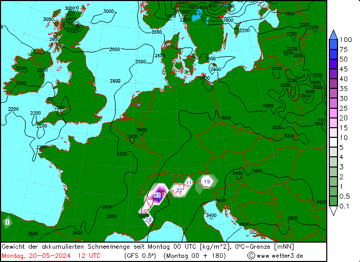
and looks like from this that Verbier was literally in the eye of the storm ❄️❄️❄️

|
|
|
|
|
|
|
|
currently 3.4c @2250m in Courchevel
fair bit of rain around for France at the moment before hopefully turning to snow again this evening
|
|
|
|
|
|
|
|
| Quote: |
Good study this week, showing how Switzerland lost a huge 3% of its glaciers in 2017.
|
Hmm. The percentage refers to summer ice mass loss, which is a normal annual process (though perhaps it was worse than normal last year) Switzerland's glaciers have been retreating for hundreds of years (apart from one small interlude - the so-called Little Ice Age.) The Victorian mountaineering literature is littered with accounts of how far the ice was known to have retreated at that time, 150-170 years ago. Perhaps this process has now sped up? No doubt some blame Brexit...
|
|
|
|
|
|
You'll get to see more forums and be part of the best ski club on the net.
You'll get to see more forums and be part of the best ski club on the net.
|
|
|
|
|
|
Windy?
Try 249kmh gust recorded at Feuersang in Gasteintal at 10.10 today...
|
|
|
|
|
|
snowHeads are a friendly bunch.
snowHeads are a friendly bunch.
|
|
@nozawaonsen, wow! I thought it was windy here in the Zillertal, but that's crazy!
|
|
|
|
|
|
And love to help out and answer questions and of course, read each other's snow reports.
And love to help out and answer questions and of course, read each other's snow reports.
|
| nozawaonsen wrote: |
Windy?
Try 249kmh gust recorded at Feuersang in Gasteintal at 10.10 today... |
Blimey. About half that here, but everything still closed.
|
|
|
|
|
|
|
|
|
|
|
You know it makes sense.
|
| Quote: |
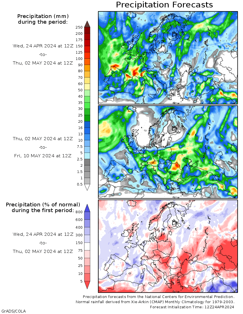
My first long term snow outlook for the European Alps for the season.
|
From a skiers perspective would it be fair to summarise this as continuing unsettled with several opportunities for more snow and the chance of some heavy snow in the southern alps in particular?
(or did I just pick up the bits I like the sound of?)
|
|
|
|
|
|
Otherwise you'll just go on seeing the one name:
Otherwise you'll just go on seeing the one name:
|
Thank you Jellybeans1000, but please could we have a glossary?
EC EPS GFS GEFS CFS MJO -NAO -AO What do they all mean?
|
|
|
|
|
|
Poster: A snowHead
|
|
|
|
Obviously A snowHead isn't a real person
Obviously A snowHead isn't a real person
|
Hope the mods don't mind me posting this...
I've added some new features to IcyBlasts.com which I hope you will find useful this season:
1) Hour by hour forecasts for resorts in Alps and Pyrenees which update every 12 hours. They use 0.1 degree data from the Meteo France Arpege model and should provide a more accurate view than the GFS based forecasts offered by many websites / apps.
2) New high resolution Arpege charts for Alps and Pyrenees which update every 12 hours.
3) Improved GFS charts which update every 6 hours.
All features can be accessed from the homepage:
http://www.icyblasts.com/
If you've got any questions feel free to ask.
Brian
|
|
|
|
|
|
Well, the person's real but it's just a made up name, see?
Well, the person's real but it's just a made up name, see?
|
|
@bwg, Can you add the Scottish highlands and English slopes into those charts at all?
|
|
|
|
|
|
You need to Login to know who's really who.
You need to Login to know who's really who.
|
|
@bwg, 0cm for Serre Chevalier and surrounding resorts????????????
|
|
|
|
|
|
Anyway, snowHeads is much more fun if you do.
Anyway, snowHeads is much more fun if you do.
|
nozawaonsen, thank you.
A further question: what is Madden Julian?
|
|
|
|
|
|
You'll need to Register first of course.
You'll need to Register first of course.
|
|
@Jonpim, it’s a weather phenomenon in the tropics which may help in anticipating medium term blocking in the northern hemisphere.
|
|
|
|
|
|
|
|
Thank you to all knowledgeable folk who contribute to this informative thread!
As a layman may I ask, although a good week away do the colours suggest warming or am I being a dunce?

Thank you!
|
|
|
|
|
|
|
|
|
@sussexmartlet, second half of December looks a bit more mobile at present. 12z GFS FI shows spells of milder and colder weather following each other as high pressure tries to exert itself over Europe. Too soon to tell at this stage however.
|
|
|
|
|
|
You'll get to see more forums and be part of the best ski club on the net.
You'll get to see more forums and be part of the best ski club on the net.
|
|
|
|
|
|
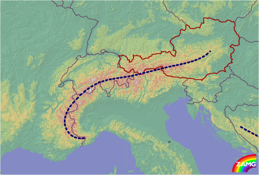
To those surprised by the difference between Serre Chevalier and Briancon...
“Worth noting how the likely temperatures change from north to south.”
|
|
|
|
|
|
snowHeads are a friendly bunch.
snowHeads are a friendly bunch.
|
| Jonpim wrote: |
Thank you Jellybeans1000, but please could we have a glossary?
EC EPS GFS GEFS CFS MJO -NAO -AO What do they all mean? |
Yeah I was thinking of writing one, explaining the drivers and models, etc.
@nozawaonsen's links do explain them pretty well though.
MJO correlates with a negative NAO or North Atlantic Oscillation, when it is in Phase 6. Which involves colder air for Europe, and more snow for the Southern Alps.
|
|
|
|
|
|
And love to help out and answer questions and of course, read each other's snow reports.
And love to help out and answer questions and of course, read each other's snow reports.
|
| olderscot wrote: |
| Quote: |
My first long term snow outlook for the European Alps for the season.
|
From a skiers perspective would it be fair to summarise this as continuing unsettled with several opportunities for more snow and the chance of some heavy snow in the southern alps in particular?
(or did I just pick up the bits I like the sound of?) |
Yes that would be a fair summary.
|
|
|
|
|
|
|
|
Still snow to fall over the coming week in the northern Alps and some strong winds about in the west at the end of the week.
Further out high pressure looks like trying to make its way across, though the models are differing in how that might play out.
|
|
|
|
|
|
You know it makes sense.
|
@nozawaonsen, as you know I'm deeply deeply cynical of forecasts in the mountains, more specifically localised ones.
Bigger picture like your post above is probably as far as you can go.
If ever there was a day to corroborate my cynicism / skepticism twas yesterday.
Not least that on the Sunday I was making arrangements with a guide friend for a potential sortie for Monday.
He was more optimistic (lives in Briancon before going home to La Grave when lifts open) about the snow that was falling heavily all day Sunday when temps forecast predicted rain +7 actual -5 and I texted him late Sunday temps now -2 saying God still might have a cruel trick up his sleeve.
Sure enough Monday Am +2 and rain. We talked on the phone about what this would do to the snow pack in the short and long term, and decided that there will be other days.
Two hours later I drive into Briancon from here at 1,400m in the rain and 10cm puddles in the parking.
As we approach Briancon I comment to the OH that they seem to have far more snow and that indeed temps were -1 and it was starting to snow really heavy.
Briancon is 8km from me and at 1,250.
We left Briancon and hour later and I've never seen so much snow falling there and so much accumulation.
We drove home and you guessed it, was still raining and +1
My friend reckoned he had 35cm when here we had around 5cm, he was totally surprised at how this could happen!
Quite bizarre but weather is on an extreme scale at the moment!
|
|
|
|
|
|
Otherwise you'll just go on seeing the one name:
Otherwise you'll just go on seeing the one name:
|
@Weathercam, isn't that exactly what was forecast though? I don't know the area/topography, but looking at the map, while technically the difference is more west-east than north-south, it looks like Serre should be just over the north side and Briancon the south?
We also have completely different weather a 15 minute drive away over the Brenner.
|
|
|
|
|
|
Poster: A snowHead
|
|
@clarky999, rather what I was thinking...
|
|
|
|
|
|
Obviously A snowHead isn't a real person
Obviously A snowHead isn't a real person
|
@clarky999, @nozawaonsen, no way guys that was just a localised freak of nature.
I'm continually looking at three or four different forecast models for our area and no way was that difference forecast and temps were nigh on 10 degrees out on Sunday!
If so on the basis of the above chart then Monetier just further up the road would not have had the snow that they had !
I'll just return to my cynical old box if I may 
|
|
|
|
|
|
Well, the person's real but it's just a made up name, see?
Well, the person's real but it's just a made up name, see?
|
|
@Weathercam, I was expecting from your report of the rain to have similar ones about Monetier.
|
|
|
|
|
|
You need to Login to know who's really who.
You need to Login to know who's really who.
|
@Hells Bells, exactly that's why it makes no sense.
I'm off up to Monetier now on the walking track they've made with the x-country skis to take a look
|
|
|
|
|
|
Anyway, snowHeads is much more fun if you do.
Anyway, snowHeads is much more fun if you do.
|
|
|
|
You'll need to Register first of course.
You'll need to Register first of course.
|
| bart_bdv wrote: |
| .....This is not freak of nature. It was the Lombarde wind that brings colder air from Italy over the border with France just to Briancon............. |
Thanks for that - just Googled it and what's weird is this Synoptically it is associated with an area of high pressure and cold air over eastern France and central Europe and a low pressure system of mild humid air south of Nice. Sometimes the lombarde is also induced by high pressure to the southeast of Europe and low pressure to the northwest along with falling pressure over western France. in that there was no active area of High Pressure over Eastern France or Central Europe yesterday and winds were very much S/SW'ly.....but some of the other factors were present "falling pressure over Western France"
Like you say weather models have much difficulty forecasting this
I'll get my coat
|
|
|
|
|
|
|
|
Weathercam, yup. And I don’t disagree with you despite you always seeming to want to imply that I do.
| nozawaonsen wrote: |
I wouldn't take a forecast beyond 7 days that seriously.
Computer models are good at giving you an idea of what the forecast is likely to be three to five days out (which is actually pretty amazing given the chaotic nature of weather). That said they can still be caught by surprise and accurately predicting precipitation in particular is very difficult. Although sometimes people ask what "locals" think the weather will be like, most (farmers, police, guides) will use the same sort of forecasting tools every else does. Locals don't have a sixth sense that can allow them to know what the weather will be like that others don't have. What they do have built on hard experience is a much better feel for how the weather will affect the local area and how that will change the conditions.
Here's something I scribbled down on forecasting at the end of the 2011 season. I think it still makes broad sense now.
nozawaonsen wrote:
"Looking at shorter term models like GFS etc. Beyond seven days any model is very subject to change. I wouldn't take it that seriously. You might get a trend. GFS provides a longer range, public set of ensembles than other models and these are easier to tie to location than others, but the ease of use does not mean GFS is necessarily a better model than others. To have any confidence in that trend you would want to see it picked up run after run and also joined by other models.
- Closer in GFS and other synoptic models start to be less useful in the 2 to 3 day range. Local variation will start to undermine them beyond the general trend.
- Mesoscale models like WRF may be more useful in the 2-3 day range.
- Right close in, on the day or day before for example, if I needed a good forecast I would almost always choose the local avalanche forecast for accuracy.
- Don't take it that seriously."
To which I'd add that beyond seven days you can't really talk about a forecast, what you have is a range of probabilities, as shown by the different coloured ensembles, which is almost always simply too great a spread to really call a forecast. You can't really make sense of these as a single snapshot. So you need to see how they evolve from run to run to give you a sense of whether certain options are looking more or less likley.
And to repeat forecasting accurate precipitation is very difficult (so be wary of any forecast that appears to say you will get 23.5cm of snow next Friday). Measuring how much has fallen afterwards is almost as difficult if not more so (so be wary of any snow report which claims 23.5cm of snow fell last Friday
|
|
|
|
|
|
|
|
|
|
@nozawaonsen, can't find a hugs & kisses emoticon
|
|
|
|
|
|
You'll get to see more forums and be part of the best ski club on the net.
You'll get to see more forums and be part of the best ski club on the net.
|
|
|
|
|
|
Much of Northern side of the Alps should see plenty of fresh snow over the next few days continuing the above average pattern of December. Maybe a drier spell and milder at times going through next week as high pressure pushes across.
|
|
|
|
|
|
|
|


