 Poster: A snowHead
|
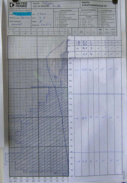
Following on from another thread ( http://snowheads.com/ski-forum/viewtopic.php?t=95774#2190986 ) and analysis of snowpack charts, does anyone care to comment on this one, taken in Chamonix late last Jan.
Better(!) pic than the original post.
Last edited by Poster: A snowHead on Tue 8-01-13 10:06; edited 2 times in total
|
|

|
|
|
|
Obviously A snowHead isn't a real person
Obviously A snowHead isn't a real person
|
|
What do you want to know about it? It's too small for me to read the detail properly, but looks like a fairly stable snow profile. I'd maybe want to have a closer look at the harder layer at about 1/3 of the way down from the surface. Rain crust? Would be curious how the softer snow above is sticking to it.
|
|
|
|
|
|
Well, the person's real but it's just a made up name, see?
Well, the person's real but it's just a made up name, see?
|
Deffo needs a better pic. I pity the person who dug it out! 
|
|
|
|
|
|
You need to Login to know who's really who.
You need to Login to know who's really who.
|
Also to add whilst snow profiles are great they are only really valid for the locality you dug it in. Typically you'll have a few dug to see what's happening to approximate a larger area.
SAIS has all their snow profiles online so you can see how things developed over time as well.
|
|
|
|
|
|
Anyway, snowHeads is much more fun if you do.
Anyway, snowHeads is much more fun if you do.
|
| Quote: |
Also to add whilst snow profiles are great they are only really valid for the locality you dug it in.
|
+1. This, plus the difficulty in truly assessing them properly, means that, in my opinion, they're not really a terribly useful tool for most recreational skiers.
Better to let the pros do the digging and get the overview via the avalanche report.
|
|
|
|
|
|
You'll need to Register first of course.
You'll need to Register first of course.
|
| stevomcd wrote: |
| What do you want to know about it? It's too small for me to read the detail properly, but looks like a fairly stable snow profile. I'd maybe want to have a closer look at the harder layer at about 1/3 of the way down from the surface. Rain crust? Would be curious how the softer snow above is sticking to it. |
Yes it was a rain crust. Snow pack was very stable.
|
|
|
|
|
|
|
|
| stevomcd wrote: |
| Quote: |
Also to add whilst snow profiles are great they are only really valid for the locality you dug it in.
|
+1. This, plus the difficulty in truly assessing them properly, means that, in my opinion, they're not really a terribly useful tool for most recreational skiers.
Better to let the pros do the digging and get the overview via the avalanche report. |
It depends on the quality of the local avalanche report. If the report is text based in a foreign language then snowpack charts by the pros could add useful extra info to the inevitable google translation. More importantly they do hint at the history of the snowpack.
|
|
|
|
|
|
|
|
The problem is that it only gives you a precise and deep analysis of a very narrow area (literally and metaphorically)
These snowpack graphs are one of the tools used to contribute to the overall snow and avalanche report. I think providing them in isolation could be misleading and open to misinterpretation.
"Avalanche level 4? But the snow-pack analysis on the slope we're skiing shows it's stable.. the level 4 must just be an average.... Let's just do it"
|
|
|
|
|
|
You'll get to see more forums and be part of the best ski club on the net.
You'll get to see more forums and be part of the best ski club on the net.
|
|
AndAnotherThing.., it's only valid for the immediate surrounds of where the pit was dug though, there is typical a lot of variance over terrain in a snowpack which is one of the reasons there is a lot of emphasis on field observations whilst traveling. All most avi bulletins are designed to do is give you a coarse idea of what the danger is and any particularly dangerous aspects and elevations. Plus it also depends on the regularity with which pits are dug and posted, at best you are going to have the snowpit data for several locations the day before so you still need to understand the effects of the weather in order to make a prediction of how that changed (and how that effected stability) in the intervening time.
|
|
|
|
|
|
|
|
meh, Yep, I'm aware of that.
feef, I'm not suggesting that they are provided in isolation. However, they might be useful for those interested in extra background information. It's like checking the 'Level' for the day, against reading the full report. The extra information in the report should give you more background against which you can make better decisions.
|
|
|
|
|
|
snowHeads are a friendly bunch.
snowHeads are a friendly bunch.
|
| AndAnotherThing.. wrote: |
meh, Yep, I'm aware of that.
feef, I'm not suggesting that they are provided in isolation. However, they might be useful for those interested in extra background information. It's like checking the 'Level' for the day, against reading the full report. The extra information in the report should give you more background against which you can make better decisions. |
neither am I.. I'm saying that someone who looks at that chart will also have to look at all the charts from the area and come up with an overall avalanche risk evaluation, and basically redo what the officials have already done. The chart on it's own (inasmuch as being used for further information) isn't going to help at all.
The overall risk is the only important thing. Unless you're going to ski the exact spot that the analysis was done, then it's no use to you for specifics.
It's not practical to dig a snow pit every few meters all the way down the slope you're going to ski, which is the only way this sort of analysis would be directly relevant to what you're about to ski on.
These graphs are only useful in devising an overall risk level, they are individual data points in a whole load of information used to evaluate the risk. Allowing people to look at individual points in ANY calculation and come up with their own assesment is a dangerous game to play.
My biggest concern would be someone who has, as I said, seen the overall risk is level 4, they look at a snow-pack analysis nearest to the area they are going to ski, maybe even the same slope, and see that it apears more stable than a level 4 might suggest so think it's safe(r), when it's not. They'll be thinking 'Level 4 is an overall average, it's fine in that specific spot'
|
|
|
|
|
|
And love to help out and answer questions and of course, read each other's snow reports.
And love to help out and answer questions and of course, read each other's snow reports.
|
Just as an example of variance take a look at the crowns pictured at the end of this article on the huge fatal avalanche in Norway last year:
http://www.ngi.no/upload/Sn%F8skred/Ulykker/Fatal%20accident_2012_19March_Sorbmegaisa.pdf
Massive differences in just a short space and completely different by a few hundred yards over.
AndAnotherThing.., lots of places do provide the snowpit data. Check this report out for example:
http://www.sais.gov.uk/page_creag%20meagaidh.asp
I actually think the SAIS reports are amazingly good.
I'm also not questioning their usefulness as extra information (if you are confident in interpreting the data) but their usefulness in aiding the understanding of a Google translated report. You're much better off finding a local patroller or guide who speaks good English and can interpret the report IMO than trying to make an educated guess from local snowpit data. You can then also quiz them for local knowledge of where in particular might be safe at the same time.
|
|
|
|
|
|
|
|
| Quote: |
It depends on the quality of the local avalanche report. If the report is text based in a foreign language then snowpack charts by the pros could add useful extra info to the inevitable google translation. More importantly they do hint at the history of the snowpack.
|
AndAnotherThing.., sure, fully agree. I meant that people digging their own pits is not terribly useful.
|
|
|
|
|
|
You know it makes sense.
|
|
www.avalanches.org is good for this stuff - starts from a map of Europe, lets you drill right down to individual pit profiles in many areas (especially Switzerland and Scotland).
|
|
|
|
|
|
Otherwise you'll just go on seeing the one name:
Otherwise you'll just go on seeing the one name:
|
| stevomcd wrote: |
| Quote: |
It depends on the quality of the local avalanche report. If the report is text based in a foreign language then snowpack charts by the pros could add useful extra info to the inevitable google translation. More importantly they do hint at the history of the snowpack.
|
AndAnotherThing.., sure, fully agree. I meant that people digging their own pits is not terribly useful. |
I agree. I was really interested in charts published by the authorities.
Thanks for all the links everyone.
|
|
|
|
|
|
|
|


