Very cloudy. The last residual precipitation (flakes from 600-800m) is resolved during the morning. However, greyness remains omnipresent throughout the day. Visibility is therefore reduced in medium and high mountains. In the Alpine plains and valleys, timid clearings could be observed in the afternoon, especially around Lake Geneva. At the end of the evening, a more significant improvement is emerging throughout the region. Moderate wind North.
Min temperatures in plains and valleys: 2/4°C
Max temperatures in plains and valleys: 8/10°C
Iso 0°C: 1300m
Forecast for Thursday, March 7, 2024
Calm down. Low clouds are numerous at the beginning of the day between the Lake Geneva Arch and Lake Bourget (sunny above 1200-1400m). This greyness is dislocated around midday. The sun is therefore radiant in the afternoon. In the rest of the region, the sky is perfectly blue from morning to evening. Light kiss.
Min temperatures in plains and valleys: 0/3°C
Max temperatures in plains and valleys: 11/15°C
Iso 0°C: 2200m
Forecast for Friday, March 8, 2024
Dunning. High clouds are already circulating in the morning, but the sun remains dominant. In the afternoon, the sky is charged more frankly by the South. The snow then falls weakly at the end of the day from 1200-1400m between the Oisans and the Haute-Maurienne. Elsewhere, the rains are very light and very scattered in the evening and the following night (flakes from 1700-1900m). The foehn gets up.
Min temperatures in plains and valleys: 0/3°C
Max temperatures in plains and valleys: 11/15°C
Iso 0°C: 2200m
Forecast for Saturday, March 9, 2024
Progressive degradation. Cloudy passages already circulate in the morning, but there are still beautiful sunny periods. On the edge of the Hautes-Alpes, the weather remains blocked, but flakes are temporarily much rarer. In the afternoon, the sky loads again on the entire region. Snowfall then gradually increased between the Oisans and the Haute-Maurienne (rain-snow limit: 1200-1400m). In the evening, an active rainy front forms west of the Jura and the Pre-Alps. Further east, towards the Savoy, the weather remains dry. Sensitive Foehn.
Min temperatures in plains and valleys: 2/5°C
Max temperatures in plains and valleys: 12/14°C
Iso 0°C: 2000m
Trends from Sunday 10 to Tuesday 12 March 2024
Sunday: precipitation is getting more widespread, snow in the middle mountains
Monday-Tuesday: remaining very cloudy with a few drops (or flakes at medium altitude)
Obviously A snowHead isn't a real person
Obviously A snowHead isn't a real person
@Rob Mackley, indeed, but that said, Meteoblue is generally pretty good, being a synthesis of many models, particularly granular in France (and Switzerland i think), taking into account topography and altitude.
Also good for trend watching.
Well, the person's real but it's just a made up name, see?
Well, the person's real but it's just a made up name, see?
@under a new name, my only issue with MeteoBlue, unless I am missing something, is that it only gives the weather for the town/village itself, not the ski mountain. So I'm looking at Mayrhofen, at 633m, and it's mentioning rain, but up top that could well be falling as snow. The easy to use sites like snow-forecast and Bergfex give different pictures at different elevations. I know I can work things out to some degree by looking at the figure for the freezing level. But I want to see actual snow figures, so I can work myself up into a gibbering frenzy of anticipation.
How are the more skilled tea readers feeling about this weekends offering?
Precipitation or no? Cold or no?
Bergfex and wepowder has Aosta and dolomites getting hit hard again and, crucially, has it cold and bright on Monday.
Wepowders initial narrative hesitation has subsided also in the latest report.
Then you can post your own questions or snow reports...
Then you can post your own questions or snow reports...
@J2R, or you can pick points on the map. E.g. Mid station Grands Montets isn't a recognised place, but I have it saved as a favourite by selecting the point off the map. (I do have to recognise the various lats and longs cos I have a few saved.).
Snow-forecast might be cute about elevation it but they're using one run of one model and not being terribly clever about that part of it, at least as I understand it. No idea re Bergfex.
Equally, the pisteurs up the Grands use MeteoSuisse for short term precip watching. Cos Chamonix is close enough that it's covered.
After all it is free
After all it is free
Next week in Les Contamines is looking like the worst of all outcomes. Mid-mountain cloud and minimal snow/rain over warm, slushy lower slopes.
Still, better a bad day in the mountains.....
You'll get to see more forums and be part of the best ski club on the net.
You'll get to see more forums and be part of the best ski club on the net.
@8611, general picture seems to be as I read it Snow in French Southern Alps including Marianne from Friday night into the Italian side / south of the Alpine ridge with a Foehn in the North and North west especially in the valleys close to the ridge , there will be no precipitation in the North and North west of the main alpine ridge until Sunday when the foehn stops blowing . Very much like last weekend but possibly not the same intensity. I suspect certain places like val d will benefit from the odd bit of snow coming over the border .
Ski the Net with snowHeads
Ski the Net with snowHeads
@8611,
I’m no Polo when it comes to the models but I can read a synoptic chart and they are suggesting a southerly track to the weekend front and a Genoa low forming, which would suggest the Southern French Alps and Italy will be the recipients of most of the snow.
snowHeads are a friendly bunch.
snowHeads are a friendly bunch.
For sure - I am most interested in the temps though. The reports from the gnarlibug suggest that having literally been snowed into the valley for a few days by the time they got up the snow was already heavy. Suspect this is primarily because of rising temps. Wondering if that will be a feature this weekend.
And love to help out and answer questions and of course, read each other's snow reports.
And love to help out and answer questions and of course, read each other's snow reports.
@Jonpim, Bergfex has been pretty good here in Selva. Snow has been forecast last night and today for a few days now. 5cm/15cm fallen. Pistes in very good condition- didn’t start snowing until 10pm but most seems to have been bashed in. Sella Ronda about a quarter as busy as yesterday. Place is absolutely packed with fair weather skiers.
So if you're just off somewhere snowy come back and post a snow report of your own and we'll all love you very much
So if you're just off somewhere snowy come back and post a snow report of your own and we'll all love you very much
@8611, at this time of year yes , light packs a punch this time of year . You won’t find cold smoke powder unless high and north facing .
You know it makes sense.
You know it makes sense.
@8611, that was the suggestion on WePowder:
WePowder wrote:
Be quick though, because from Friday the southern föhn returns and it gets very mild, also at higher altitudes. So, as with last week’s föhn, much of this snow will disappear again very quickly. The fresh snow is extra sensitive to this snow eater.
It happened the last time as well, 10 days ago – by the middle of the afternoon the snow was already developing a wind crust and getting tricky to ski.
Otherwise you'll just go on seeing the one name:
Otherwise you'll just go on seeing the one name:
Yep exactly
Poster: A snowHead
Poster: A snowHead
Have to say it's what I've been saying for quite a while, plus the exposed ground is no longer frozen so that expediates the melt.
When it snows this time of year you have to ski it first thing as by 11:00 below 1850 starts to get heavy, as the OH found out two days ago.
And as @Rob Mackley, mentions, extra hours of daylight now and the sun higher throws additional spanners in the works in that aspects that were not susceptible to crust now are.
Obviously, all this is only relevant to off-piste/ski touring.
The only plus point is that we have very good coverage at altitude, and a crust developed before the stronger winds of today will mean hopefully we have more of a carpet as opposed to wind-affected snow for the freeze/melt to get to work on and provide classic smooth corn.
And it looks like, for us at least, in Serre Che, apart from yr.no's optimistic forecast it's now more of a dribble for Friday and the weekend, though Queyras & Piemonte still looking good.
I'm on a course this weekend so will be interesting to see where we end up!
Obviously A snowHead isn't a real person
Obviously A snowHead isn't a real person
Looks like the battle of the Meteos this weekend for ADH!
Météo blue has pretty decent snowfalls forecast for the weekend to Monday.
Meteociel doesn’t have as much for the same timeframe.
Cmon the blue!
Well, the person's real but it's just a made up name, see?
Well, the person's real but it's just a made up name, see?
Alpinebear wrote:
Looks like the battle of the Meteos this weekend for ADH!
Météo blue has pretty decent snowfalls forecast for the weekend to Monday.
Meteociel doesn’t have as much for the same timeframe.
Cmon the blue!
MeteoFrance and Bergfex show precipitation from Friday to Monday.
Did I read years ago that a retour d'ouest or possibly just some weather system that favours snow in the Dolomites, when it comes in it often comes in a set of multiple systems that deliver snow over and over again? Is that what we are seeing now? Looks like Italy getting hit like five times in a row
Anyway, snowHeads is much more fun if you do.
Anyway, snowHeads is much more fun if you do.
8611 wrote:
Did I read years ago that a retour d'ouest or possibly just some weather system that favours snow in the Dolomites, when it comes in it often comes in a set of multiple systems that deliver snow over and over again? Is that what we are seeing now? Looks like Italy getting hit like five times in a row
From recollection, I don't recall snow hitting the Dolomites in multiple waves like now. Usually it snows then you see nothing for several weeks. Might be different further west in Aosta for example.
@8611, I like actually to refer to the system as a Genoa Low rather than retour d’ouest which is more a phenomenon.
As a rule a thumb I like to think in a season that the alps are hit by many West / North west or North weather flows that deliver more often but less snow whilst the southern alps get two or three or less Genoa lows a season but when they hit they are very plentiful . I do remember two or three season in the last 15 yrs or so when the Genoa lows have been like buses as they have been in the last few weeks .
Then you can post your own questions or snow reports...
Then you can post your own questions or snow reports...
@Rob Mackley, it's a Retour D'Est and not a Ouest, major difference!
And unlike Atlantic low-pressure systems that can track across the UK in a matter of hours the "Genoa Low" will often not budge for a couple of days and will continue to dump bringing "weather" on a continually rotating basis from the East, hence "Retour d'Est".
Last edited by Then you can post your own questions or snow reports... on Thu 7-03-24 15:08; edited 1 time in total
After all it is free
After all it is free
Christ you'd think I'd get the direction right!
You'll get to see more forums and be part of the best ski club on the net.
You'll get to see more forums and be part of the best ski club on the net.
@Weathercam, yes Doh I blame @8611,
Ski the Net with snowHeads
Ski the Net with snowHeads
Quote:
MeteoFrance and Bergfex show precipitation from Friday to Monday.
Wepowder showing pretty much Zilch.
snowHeads are a friendly bunch.
snowHeads are a friendly bunch.
@coldrainsnow, I don't think 20-30+ cm at AdH is Zilch?!
And love to help out and answer questions and of course, read each other's snow reports.
And love to help out and answer questions and of course, read each other's snow reports.
Quote:
@coldrainsnow, I don't think 20-30+ cm at AdH is Zilch?!
Ack sorry you're right AdH looking good! Got my threads confused, showing very little for Haute-Savoie next week but Bergex is much more optimistic.
So if you're just off somewhere snowy come back and post a snow report of your own and we'll all love you very much
So if you're just off somewhere snowy come back and post a snow report of your own and we'll all love you very much
@coldrainsnow, Looks like the main models are coming to a broad consensus in the South at least
You know it makes sense.
You know it makes sense.
jimmybog wrote:
8611 wrote:
Did I read years ago that a retour d'ouest or possibly just some weather system that favours snow in the Dolomites, when it comes in it often comes in a set of multiple systems that deliver snow over and over again? Is that what we are seeing now? Looks like Italy getting hit like five times in a row
From recollection, I don't recall snow hitting the Dolomites in multiple waves like now. Usually it snows then you see nothing for several weeks. Might be different further west in Aosta for example.
Rare, but it does happen - as per my post on the previous page, the last time (I can remember) was the winter of 2013/14. Not sure if it's the sort of thing that happens on a ~10 year cycle or more rare/common than that. Snow for Sud & Out Tirol for this weekend massively downgraded on the latest runs anyway.
Otherwise you'll just go on seeing the one name:
Otherwise you'll just go on seeing the one name:
Weathercam wrote:
@Rob Mackley, it's a Retour D'Est and not a Ouest, major difference!
And unlike Atlantic low-pressure systems that can track across the UK in a matter of hours the "Genoa Low" will often not budge for a couple of days and will continue to dump bringing "weather" on a continually rotating basis from the East, hence "Retour d'Est".
I skied in Slovenia a few times, talking to chap there he said the Retour D'Est was great for them too, it wouldn't happen often, once or twice a season, but when it came, it pulled weather up the Adriatic, loaded the clouds with moisture and the first thing it hit was the Julian Alps and it dumped 1m plus at a time and then they were set for the season.
Poster: A snowHead
Poster: A snowHead
Hey @polo,
Do you know what's going on next week, weather seems to be really chopping and changing ever few hours. Before there was some indication of temps and pressure, but even the ensemble is changing so much. Do you know the cause for this?
Might be only changing a lot for Pyrenees but trying to figure out the cause of the wild swing changes.
Obviously A snowHead isn't a real person
Obviously A snowHead isn't a real person
And so like all sensible weather watchers, we now "Wait and See" what the Weather / Snow God's (Ullr, name of our dog) have decided to let us have down in this part of the world over the next 48hrs or so and then compare that with all the disparate models
Supposedly first flocons are due 15:00 onwards, and then based on that other well-known meteorological factor, "Sods Law" as I'm on a course this weekend we're bound to get too much snow, even though it is avalanche focused, but out on the mountain.
Well, the person's real but it's just a made up name, see?
Well, the person's real but it's just a made up name, see?
@Weathercam, I'll buy you a beer for booking onto that course if it works out well
Next week looks like another belter with yet more snow from Sunday accompanied by cold temps and then sun later in the week. And that is on top of a base at altitude which is already fabulous
The Bec des Rosses is as filled in as I’ve ever seen it. Steep skiing / touring season is looking very promising and it could be a great year for an Easter trip (at altitude)
Anyway, snowHeads is much more fun if you do.
Anyway, snowHeads is much more fun if you do.
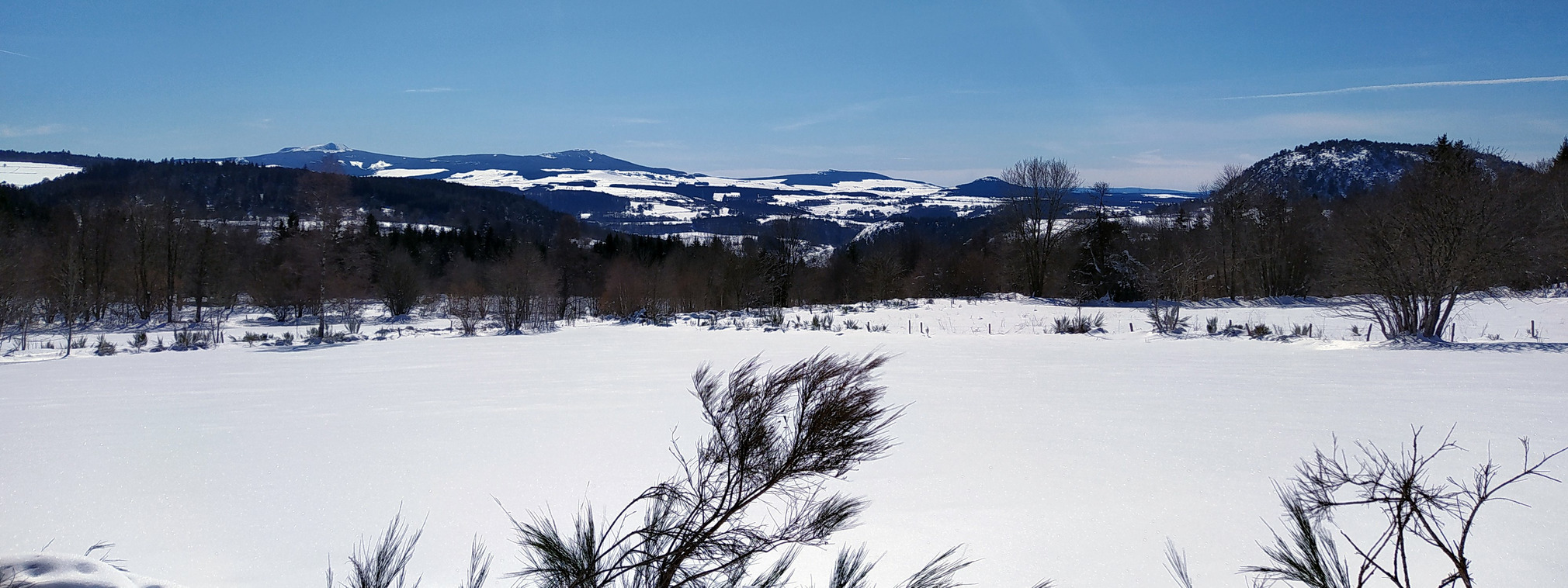
This is what the Retour d'Est did for the Ardeche, Super clear day yesterday, you could see the clearly see the Alps, or see the alps clearly.
As Weathercam points out, on warm ground with long days so won't stick around. A Cevenol is going to hit the region this weekend.
@Theobane, same elsewhere (I'm looking at the eastern Alps). It looks like there's a big area of weak low pressure which I understand is a bit messy to forecast:
Then you can post your own questions or snow reports...
Then you can post your own questions or snow reports...
@davidof, Saturday's Paris Nice stage is being diverted due to adverse weather conditions too
After all it is free
After all it is free
leggyblonde wrote:
@davidof, Saturday's Paris Nice stage is being diverted due to adverse weather conditions too
they often have a few flakes of snow en route but the storm that is currently hitting the Ardeche is going to blow into the Maritime Alps.


 Poster: A snowHead