Poster: A snowHead
|
The Snowheads discussion about snow is a bit like the appearance of "seasonal goods" in British supermarkets; earlier and earlier each year.  But more fun! But more fun!
|
|

|
|
|
|
Obviously A snowHead isn't a real person
Obviously A snowHead isn't a real person
|
Not sure about this BS talk.......Brussel Sprouts  are a regular feature early Autumn, and this thread used to start in June, with several snowy September periods previously modelled / discussed. But what's more likely this October? What chestnuts are showing in the numerical weather predictions? Are the GFS charts just a load of pumpkin? are a regular feature early Autumn, and this thread used to start in June, with several snowy September periods previously modelled / discussed. But what's more likely this October? What chestnuts are showing in the numerical weather predictions? Are the GFS charts just a load of pumpkin?
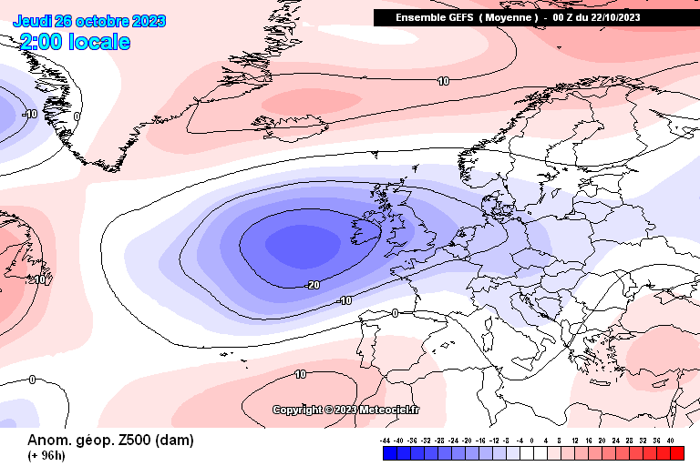
First a look at how close the deep low to the east gets to austria on sunday, while the UK goes all indian. Will likely see more of this pattern as El Nino takes hold, but hopefully without the deep tropical low mid atalntic, which would shift the pattern west.

Looking 10 days out to the 15th, the 3 main anomaly charts show a mix of SW and NW flow into northern france.....low pressure not quite reaching far enough south, but I'd take the middle one (GEM).
  
Even further out the EC42 model for week 3 (they always start on a monday, so 16th-23rd) doesn't offer much hope with an overall SW pattern, lows from the north want to link with the south atlantic low, like last xmas. But this range is far from reliable, slight changes could produce a decent cold spell.

Which is exactly what GFS Op run has shown a few times.....a real beauty, but 16th Oct, without much support. I'd give it less than 10% chance right now. Hope-casting.

There may well be date records broken in the UK on the weekend, but not going to trouble the all time Oct record.....29.9C in Kent 2011. Other records of interest....in 1906 it reached 35.6c in September. The Nov UK record is 22.4c (1/11/15), and incredibly it has reached 20c in Larig Scotland as late as 24th Nov, also in 1906.
https://www.metoffice.gov.uk/research/climate/maps-and-data/uk-climate-extremes
Enjoy the heat while it lasts, big change coming (esp UK), could see snow from 11-12th up north.
|
|
|
|
|
|
Well, the person's real but it's just a made up name, see?
Well, the person's real but it's just a made up name, see?
|
| Quote: |
| Enjoy the heat while it lasts, big change coming (esp UK), could see snow from 11-12th up north. |
Now we are talking 
|
|
|
|
|
|
You need to Login to know who's really who.
You need to Login to know who's really who.
|
|
|
|
Anyway, snowHeads is much more fun if you do.
Anyway, snowHeads is much more fun if you do.
|
Remarkable, @Peter S. Fairly glad to say I'm due to be enjoying the Indian Summer in my son's garden in Dundry, with stunning views over Bristol.  But I don't underestimate what's going on. Quoting odd days of unusual temperatures (it was even hotter in Little Piddling in March 1886) means nothing. We've always had weather. But the statistics of long term trends are something else...... But I don't underestimate what's going on. Quoting odd days of unusual temperatures (it was even hotter in Little Piddling in March 1886) means nothing. We've always had weather. But the statistics of long term trends are something else......
|
|
|
|
|
|
You'll need to Register first of course.
You'll need to Register first of course.
|
|
@Peter S, indeed! A fine day for the Aviemore half marathon (tomorrow)…
|
|
|
|
|
|
|
|
|
|
|
|
|
|
|
|
You'll get to see more forums and be part of the best ski club on the net.
You'll get to see more forums and be part of the best ski club on the net.
|
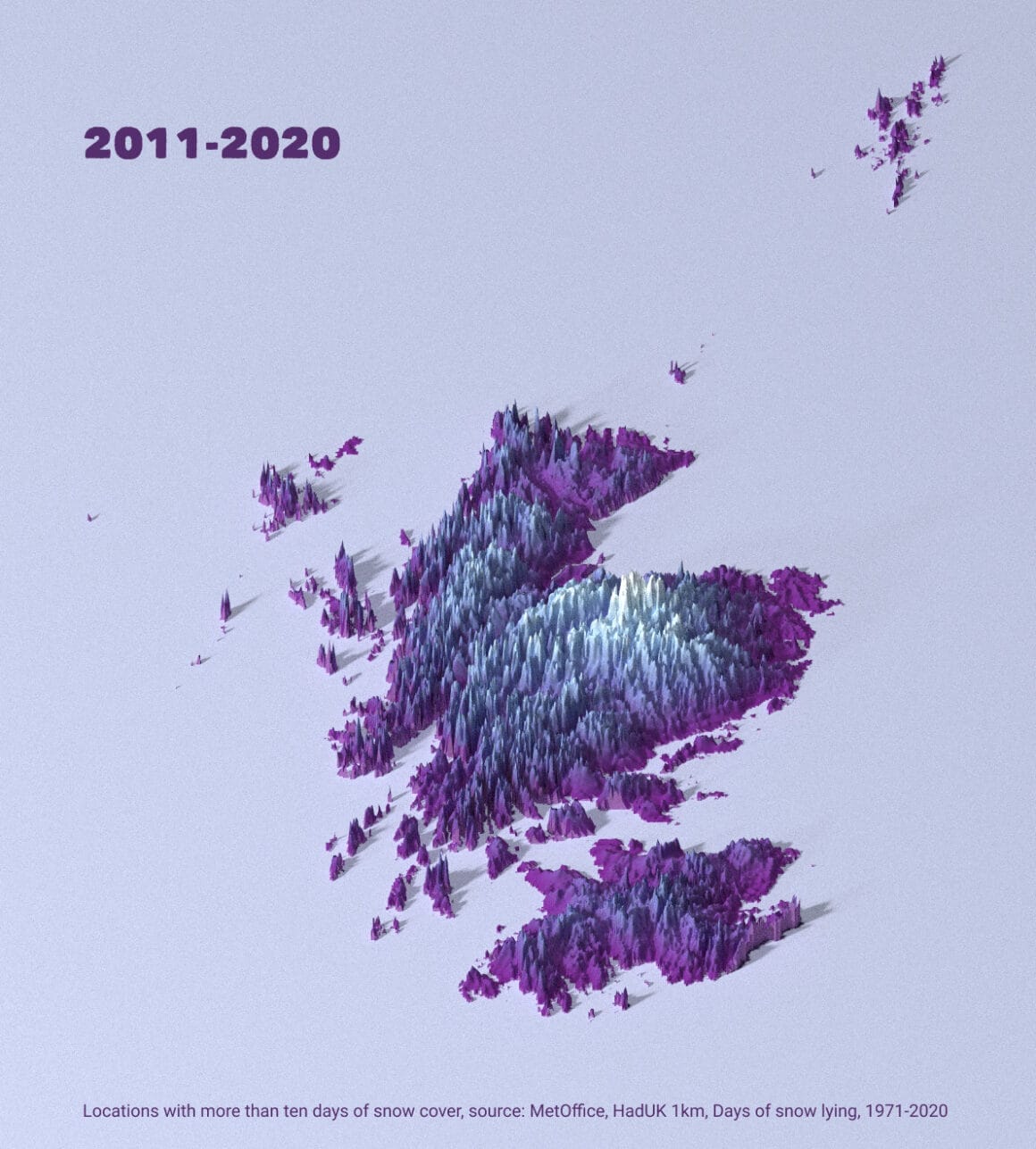
Statistics.....yes the starting date is very important, so many comparisons start in the 1970's, which misses the cooling trend during the 40's-70's.
Anyway, it's interesting that 2013 had the highest value of snow days at Cairngorm in the last 50 years, while 2020 had the lowest. For the whole of Scotland the snowiest year in the last 50 years was 2010, with 2020 again being the lowest. So there's been a big drop from those extreme snowy readings in 2010 and 2013, to 2020. A very short period of data to support the 'crisis' heading.
Also can see the 80's were snowier than the 70's.....but I doubt anyone was suggesting a 10 year increase in snow was predicting snowier winters into the future, which would have been very wrong. In general it's showing that snow cover has indeed declined since the 80's, but with certain snowfall records still being broken in a good way as late as 2013.
Snow cover across the NH has been increasing quickly recently, catching up with 21-22 levels after a warm August. It's something often tracked by winter enthusiasts as more snow cover creates a feedback loop for reflecting heat and sustaining colder air sources into europe (eg from the north and north east). Scandinavia in particular is getting snow cover relatively early, but Siberia, Alaska, North Canada also doing well.

Looking back at how the latest 10 day forecast did, for the 15th (above)....there has been a shift in the right direction, as the low anomaly is slightly further south than shown last week. GEM was once again the most accurate of the 3, which have all converged to this now. GFS showed too much SW influence, and ECM was too far north with the low.

But the cooler NW air still doesn't quite reach the alps, stopping in northern France (15th). Beyond this the models have been showing a wide range of possible outcomes, from scandi high to flat westerly, to SW mild, and now even a cold UK high. So a lot of noise, but again moving in the right direction with the latest charts, especially ECM, 18th

It's not supported by the other 2 yet, so not a reliable forecast. But interesting to see another Omega block, and this one at much more favorable latitude, bringing cold to eastern alps.
I think this mid Oct timeframe (14-18th) might be a short lived chance at cold, as the EC42 continues to show a SW flow getting reestablished week 3 to our west.
Again it has improved from first showing (lower east euro heights) but not enough to change the overall air source much (direction of isobars). Probably close to avg temps unless that northern blocking (towards Iceland-norway) really takes hold.

|
|
|
|
|
|
|
|
Scotland is being hammered by global boiling.
Scotland resorts used to open Oct to Jun.
Now, they struggle with Dec to Apr.
Ski seasons there are trending (considerably) shorter.
Back to the present day... Eastern Alps badly needs that colder weather forecast.
Hintertux glacier at 3200m today is black and very melty again.
|
|
|
|
|
|
snowHeads are a friendly bunch.
snowHeads are a friendly bunch.
|
| Quote: |
Now, they struggle with late January to early February.
|
FIFY 
|
|
|
|
|
|
And love to help out and answer questions and of course, read each other's snow reports.
And love to help out and answer questions and of course, read each other's snow reports.
|
10/10 on the global boiling reference. Good luck to Scotland, and any slopes in France below 2000m.
A few 12z runs suggesting mid month drama still on track.
|
|
|
|
|
|
|
|
Cold and moist air is infiltrating the upper West Coast, aka PNW. The low pressure trough is coming out of the Gulf of AK. It will make its way through lower BC and into the interior Mountain West and drop some moisture at higher elevations in the form of snow. Montana, Northern Idaho, Tetons, Wasatch and Northern Colorado Rockies will see snow fall at the 9,000 foot level. 5-10 inches is on the way.

|
|
|
|
|
|
You know it makes sense.
|
|
GFS for Zermatt shows temps dropping to below freezing at village level from around the 20th. Here’s hoping.
|
|
|
|
|
|
Otherwise you'll just go on seeing the one name:
Otherwise you'll just go on seeing the one name:
|
@twoodwar, we had a hard frost in the garden for a good few nights about a week ago (?) - now? not so much. It was 27C in the garden on Sunday afternoon 
|
|
|
|
|
|
Poster: A snowHead
|
Latest ECM global boiling projections for Nov-Dec-Jan. There is a 70-100% likelihood that surface temps will be above the upper tercile (third) of the historical range. And this is based on very recent climatology, can't blame the 70's for this one, the comparison period is 1993-2016. Much hotter than recent averages, so any snow to low altitude will be an unexpected bonus, got it.

Back in the real world, cold starts to arrive tomorrow, but doesn't really drop until the weekend, frosty up north.

The incoming NW low does cross the alps as well, hard to say FL, but I'd guess 2400m west and 1500m austria.....very broadly.
The cold air hangs around for a few days, so the next low coming from the med might lead to snow for southern alps next week. Bit far for any detail but support is building for northern blocking and some very cold air waiting in the wings to the east.
The usual caveat with modeling a NE undercut is that we often see the models over-estimate the latitude of the block, ie when they show high's over norway, they often end up nearer to UK/Germany as time runs down. In this case though there is cross model support getting repeatedly shown, so about as good as it gets at just 6-7 days away, but you really need to see this at just 3-4 days out to have confidence.
Little agreement on the 3 mean anomaly charts at 8-10 days, so it's all noise beyond the weekend......here are some random samples from the far reaches of Fantasy Island. Not a forecast.
We don't want to see latest ECM Op...sinking high, others much colder
   
|
|
|
|
|
|
Obviously A snowHead isn't a real person
Obviously A snowHead isn't a real person
|
|
Some forecasts (for now) suggest 20-40cm of snowfall in Northern Italy above 1500-2000m during the week of Thurs 19 to Thurs 26 Oct...
|
|
|
|
|
|
Well, the person's real but it's just a made up name, see?
Well, the person's real but it's just a made up name, see?
|
|
|
|
You need to Login to know who's really who.
You need to Login to know who's really who.
|
I've been tracking the C35 updates: 8 long range models plus their combined output.....NDJ doesn't look as good as it did in August, with the Sep and Oct updates showing a positively tilted atlantic low (SW-NE), with blocking to the north and east. Very hard to read much into these as they are 3 month averages, but clearly UKMO is one of the better options. Performance wise though they are very hit and miss, even for the current month. ie The updates are released on 10th of each month, so they pretty much only have to forecast the last 2 weeks, as the 10-17th is usually already 80% accurate.
Despite this there is significant variability between each model as well as the combined projection vs actual outcome of the current month. So if they can't agree 2-3 weeks away it's hard to see how 3-4months will be any better. One or two of them will be close to the mark......but little consistency. FWIW the ECCC model has been close more often than not this year.....it's the long range version of the Canadian GEM model and focuses a lot on ocean data.
In the near term, I think the key timeframe is next mon-tues. Models are split on how high the initial UK block gets, and how far east/west. Small differences will have a big impact in the week that follows, ie sink or swim. We want to see high pressure heading north and not getting too far east initially. GFS 00z shows another ideal evolution overnight with very cold easterly undercut into the alps, but none of the other models are as good right now, so low odds still. Plently of cold air around, the only question is how far west it advects and if we get some med lows. Further out a Scandi high looks more and more likely, but it's what is under it that counts for the alps.
Some charts.....I'll do mostly thumbnails now on for less scrolling time. Last 2 show the big differences between latest Op runs, ECM sinks and GFS swims for 19th.
     
|
|
|
|
|
|
Anyway, snowHeads is much more fun if you do.
Anyway, snowHeads is much more fun if you do.
|
|
|
|
You'll need to Register first of course.
You'll need to Register first of course.
|
Next week's snow (for Italy) has become rain...
Charts are all over the place.
|
|
|
|
|
|
|
|
|
|
|
|
|
|
@polo, this is all fascinating stuff, thank you.
|
|
|
|
|
|
You'll get to see more forums and be part of the best ski club on the net.
You'll get to see more forums and be part of the best ski club on the net.
|
|
Presumably plenty of precipitation on the radar so the snow making reservoirs will be full .
|
|
|
|
|
|
|
|
|
|
|
snowHeads are a friendly bunch.
snowHeads are a friendly bunch.
|
|
|
|
And love to help out and answer questions and of course, read each other's snow reports.
And love to help out and answer questions and of course, read each other's snow reports.
|
| polo wrote: |
Latest ECM global boiling projections for Nov-Dec-Jan. There is a 70-100% likelihood that surface temps will be above the upper tercile (third) of the historical range. And this is based on very recent climatology, can't blame the 70's for this one, the comparison period is 1993-2016. Much hotter than recent averages, so any snow to low altitude will be an unexpected bonus, got it.
|
ok I'll have to think about a season pass then.
|
|
|
|
|
|
|
|
@davidof, I'm already committed to lower altitude, models be damned... what would Heisenberg do? Still waiting for the sequel btw.
Meteo France Oct seasonal update looks like a very slow burner....might get a few weeks in March.
Caveat: their monthly Oct forecast was tragic.
Significant differences on the ensembles regarding FL next weekend....eg ECM warmer than GFS.
But some nice GFS Op runs showing up for the final week, that fit within the expected anomaly.
EC46 oct 23-30

|
|
|
|
|
|
You know it makes sense.
|
Some charts again teasing 50cm / 20in for the southern Alps (Italy) at the end of the month.
Southeast Australia got a rare (late) sprinkle yesterday.
East Scotland and northeast England got a dusting.
Colorado high country still not open yet. Everyone waiting on A-Basin and others.
|
|
|
|
|
|
Otherwise you'll just go on seeing the one name:
Otherwise you'll just go on seeing the one name:
|
| polo wrote: |
| @davidof, I'm already committed to lower altitude, models be damned... |
last year in quite a few of the easy to reach resorts the season was end of Jan to end of Feb; I'll hold off to the end of the month and wait for more beta.
|
|
|
|
|
|
Poster: A snowHead
|
|
|
|
Obviously A snowHead isn't a real person
Obviously A snowHead isn't a real person
|
|
|
|
Well, the person's real but it's just a made up name, see?
Well, the person's real but it's just a made up name, see?
|
Air temp + wind direction for snow.
Ground temp for frost.
Zermatt is made from African rock (not European).
It's got some funky sh*t going on.
|
|
|
|
|
|
You need to Login to know who's really who.
You need to Login to know who's really who.
|
Looking promising for early snow!

|
|
|
|
|
|
Anyway, snowHeads is much more fun if you do.
Anyway, snowHeads is much more fun if you do.
|
|
|
|
You'll need to Register first of course.
You'll need to Register first of course.
|
|
Excellent let's hope the start of winter
|
|
|
|
|
|
|
|
it’s now 21st October- no further updates on the season forecast?  I am interested in Ischgl infer and need to know if the Crystal snow guarantee is worth it (will it ever be so bad to have 50% of runs closed?) I am interested in Ischgl infer and need to know if the Crystal snow guarantee is worth it (will it ever be so bad to have 50% of runs closed?)
|
|
|
|
|
|
|
|
Long range models update their seasonal forecasts around the 10th of each month, Oct update was a very mixed bag, not much to say except that ECM and others looked mild, while UKMO colder.
Certainly nice to have some autumnal weather here now, fire lit, thermals on and fondue for dinner.....but that's just because I want it to be colder than it actually is. Pretty average looking temps in the outlook for the west, a bit milder to the east, all because the atlantic lows are tending to stall around the 27-28th.
Often after a scandi undercut that regresses west towards greenland, you get northerly flow in behind. Something to watch out for into early Nov but at the moment EC46 model is sticking with a scandi high in the medium term and SW flow into alps next week. So FL in the NW hovering around 2500m, or 6-7c at 850hpa on average.
Still a lot of rain to come over UK / parts of europe, as the lows have nowhere else to go. Need to see them push east to bring colder air.
The polar vortex is well organised in the strat currently but more disjointed at trop level. So without a strong top-down connection it allows high pressure to build to our north, prolonging the slightly negative AO and NAO. But all that means is certain background features are assisting with getting low pressure towards europe for now. The PV keeps strengthening it's westerly spin until peaking in Jan, baring an SSW. The stronger and more connected it is, the more likely europe gets atlantic driven wet weather, or even a high block, ie less chance of cold. While periods of weaker than normal strat winds will help with getting cold to mid-lattitudes. The easterly QBO phase we are in this winter should help weaken strat winds.
New link for anyone interested in the GFS forecasts and charts for the PV.
https://stratobserve.com/misc_vort3d
Also ECM ensembles of 10hpa winds (strat PV strength) here. Looks like winds will weaken into month end before heading back above average.
https://charts.ecmwf.int/products/extended-zonal-mean-zonal-wind?area=nh&base_time=202310200000
Charts: EC46 next week, GFS 3D PV, strat PV strength, and the not-as-good means for 27/28th
     
|
|
|
|
|
|
You'll get to see more forums and be part of the best ski club on the net.
You'll get to see more forums and be part of the best ski club on the net.
|
Northern Rockies and Northern Plains due their first big snowstorm of the season next week. Perhaps 6in across parts of southern Canada and northern US.
Western and Eastern Europe still looking way too warm. The window for a good early-season in the Alps is starting to close.
|
|
|
|
|
|
|
|
Here's the GFS mean for 26th-30th. The low off SW Ire tries to move east, gets turned back, tries again, gives up.
Feels like a missed oppurtunity for cold and snow......-NAO, weak strat, northern blocking, southerly jet, low pressure europe. But it's Oct, 2 months of early season to go.
Problem is good set ups don't last long, so only a matter of time before a blocked dry phase returns. But no consesus / view yet on early Nov.
In terms of temps, as usual depends what reference period. Compared to last century it's looking warm. EC46 uses last 20years, and still slightly above average. While individually there are more average to below avg days on the ECM model for the west next week.....but yeah once the low dips towards spain it mixes in mild air for central europe with cold mostly confined to scandinavia and west iberia.
  
Still scope for mid level snow in parts of alps....maybe even down to 2000 on occasion
|
|
|
|
|
|
|
|